 LOWA Renegade EVO GTX MidGORE-TEX, 3 widths, resolableCheck price on Amazon →
 Hydro Flask Wide Mouth 32ozinsulated, durableCheck price on Amazon →
 Osprey Talon 22ventilated back, pole carryCheck price on Amazon →
 Adventure Medical Kits Ultralight Watertight .7day-hike specific, waterproofCheck price on Amazon →
 Black Diamond Spot 400-Rrechargeable, comfortableCheck price on Amazon →
Crabtree Falls at a glance: A 3.3-mile out-and-back near Tyro that climbs alongside a series of cascades billed as the highest vertical-drop waterfall in the eastern United States. Rated moderate, with a steady stair-and-switchback climb past multiple overlooks. The wet rocks here are genuinely deadly and have claimed many lives, so stay on the trail and behind railings. There is a day-use fee, dogs are welcome on leash, and the falls run best after rain.
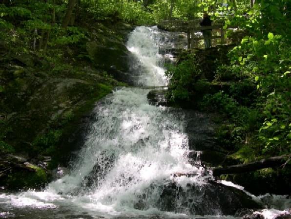
Crabtree Falls is a showstopper in the Blue Ridge of central Virginia, a chain of cascades that tumbles some 1,200 feet down the mountainside in a series of dramatic drops. Billed as the highest vertical-drop waterfall in the eastern United States, it is not a single plunge but a staircase of falls, and the well-built trail climbs alongside it with overlooks at each major cascade. Reviews rate it among the best waterfall hikes in the region, with a serious, recurring warning about the danger of the wet rocks that has to be taken seriously.
The trail begins near the lower parking area and climbs steadily up the mountainside, closely following the cascading water. Built with stone steps, switchbacks, and a series of railed overlooks, it delivers a new view of the falls every few minutes as you ascend, each cascade different from the last. In total the water drops through five major cascades, and the trail is laid out to showcase each one in turn as you climb. The lower overlooks are reached quickly and are rewarding in themselves, so hikers can choose how far up the mountain they want to go.
The full trail climbs to the top of the falls, gaining significant elevation over its length, and the upper reaches offer both the highest cascades and a view out over the Tye River valley. The whole way, the sound and sight of falling water is constant, which is the trail’s great appeal. It is a hike defined by its waterfall rather than a summit, with the reward spread across the entire climb.
The overlooks exist for a serious reason. The rocks alongside the falls are deceptively slippery, coated in algae and spray, and climbing on them has caused numerous deaths over the years, making Crabtree one of the deadliest waterfalls in the region for those who leave the trail. Reviews are emphatic and unanimous: stay on the trail, use the overlooks, and keep behind the railings, especially with children.
Moderate is a fair rating, with the difficulty being the steady climb rather than any technical terrain. The trail gains real elevation over its length, so reaching the top is a genuine workout, though the stone steps and switchbacks keep the footing manageable. Most hikers reach the upper falls and return in around two hours, and many turn around at one of the lower overlooks for a shorter, still-rewarding outing.
Conditions are generally good on the well-maintained trail, though it gets muddy after rain and the steps can be slick. The real hazard is not the trail itself but the temptation to step off it onto the wet rocks, which is where the danger lies. The honest read is an accessible, rewarding waterfall climb whose only serious risk comes from leaving the marked path.
The trail is open year-round and rewarding in every season. Spring brings the strongest water flow and wildflowers, showing the cascades at their most powerful, while fall pairs the falls with color across the valley for the most scenic time of year. Summer is popular and shaded on the forested climb, though the trail can be busy on weekends and an early start helps.
Winter is quieter and can bring dramatic ice to the cascades, but the steps and wet rock become genuinely hazardous with frost and ice, so traction and extra caution are essential in the cold months. In any season, the falls are most impressive after rain or snowmelt, though that same water makes the adjacent rocks even more dangerous, reinforcing the need to stay on the trail.
Parking is at the lower trailhead, and there is a day-use fee to use the area, so bring payment or check current methods before you go. The lot is medium to large and fills on nice weekends, so an early arrival helps, and there are restrooms at the trailhead, a welcome convenience for a waterfall hike.
Dogs are welcome on leash and this is a popular hike for them, though the steps and crowds are worth considering with a dog along. Wear shoes with good grip for the stone steps and wet sections, carry water for the climb, and above all, keep yourself and your group on the trail and behind the railings. The overlooks provide excellent views without any need to approach the dangerous rocks.
Crabtree Falls sits near Tyro in the George Washington National Forest, off the Blue Ridge Parkway corridor in central Virginia, which makes it easy to combine with a Parkway drive or nearby trails. Its status as the highest vertical-drop waterfall in the East, combined with a well-built trail and multiple overlooks, makes it a standout destination for waterfall lovers.
Crabtree Falls earns excellent marks from the many people who hike it, with the overwhelming majority calling the cascades spectacular and the trail well built, while echoing a serious and consistent warning about the deadly wet rocks off the trail. The recurring practical advice is clear: enjoy the falls from the overlooks, never climb on the rocks, and expect a steady stair climb and a day-use fee.
That is the honest summary of Virginia’s great cascade. It offers a genuinely spectacular series of waterfalls with overlooks the whole way up, rewarding for the climb as long as you respect the danger of the wet rock. Arrive early, wear grippy shoes, stay on the trail and behind the railings, and Crabtree Falls delivers one of the finest waterfall hikes in the eastern mountains.
LOWA Renegade EVO GTX MidGORE-TEX, 3 widths, resolableCheck price on Amazon →Hydro Flask Wide Mouth 32ozinsulated, durableCheck price on Amazon →Osprey Talon 22ventilated back, pole carryCheck price on Amazon →Adventure Medical Kits Ultralight Watertight .7day-hike specific, waterproofCheck price on Amazon →Black Diamond Spot 400-Rrechargeable, comfortableCheck price on Amazon → Patagonia Torrentshell 3L Jacketdurable, trail + everydayCheck price on Amazon →
 Darn Tough Hiker Micro Crew Midweightlifetime warrantyCheck price on Amazon →
 Black Diamond Pursuit Trekking Polescork grip, lightweightCheck price on Amazon →
 Sawyer Squeeze Water Filterultralight, standard threadsCheck price on Amazon →

