LOWA Renegade EVO GTX MidGORE-TEX, 3 widths, resolableCheck price on Amazon →
 Hydro Flask Wide Mouth 32ozinsulated, durableCheck price on Amazon →
 Osprey Talon 22ventilated back, pole carryCheck price on Amazon →
 Adventure Medical Kits Ultralight Watertight .7day-hike specific, waterproofCheck price on Amazon →
 Black Diamond Spot 400-Rrechargeable, comfortableCheck price on Amazon →
What to Expect
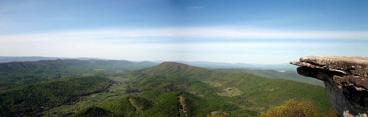
Spy Rock sits at 3,680 feet on the AT in the George Washington National Forest, and the summit is a wide slab of bare granite with a 360-degree view that stops most people in their tracks. To the north you can see Three Ridges and The Priest — two of the most prominent summits in central Virginia. To the south the Rockfish Valley spreads out below you, and on clear days the Blue Ridge rolls on in every direction. It’s one of those summits where you understand immediately why people hike.
The standard approach uses a USFS road off VA-56 near Montebello, about 50 miles from Charlottesville. You park at a small pullout and follow a short connector trail to the AT, then turn south. The trail is well-maintained through a mixed hardwood forest that opens up completely at the summit rocks. The final push is steep for about a quarter mile — loose soil and exposed roots — but nothing technical. At 2.6 miles round trip it’s genuinely short, which makes the quality of the views feel outsized.
The summit rocks are large enough that even a crowd of people can spread out and find space. There’s no shelter and no shade at the top, so bring water regardless of season. You’ll likely share the summit with AT thru-hikers filtering water and taking a break.
Difficulty
Moderate. The total distance is short but the trail climbs about 900 feet with one sustained steep section near the top. The footing is rooty in the middle stretch and can be slick after rain. Most fit hikers with trail shoes will have no trouble. The brevity makes it accessible — 1.5 to 2.5 hours round trip depending on pace and how long you sit on top.
Best Time to Go
Late April through May brings wildflowers in the lower forest. The exposed summit means you’ll feel wind year-round, so an extra layer is worth carrying even in summer. October color peaks around the third week and the views from the summit get even better once the leaves drop. Winter is doable on most days but check road conditions on the USFS access road first — it’s unpaved and can be rough after snow.
Before You Go
Access is via VA-56 east from Vesuvius, then a right onto USFS Road 42 (Crabtree Falls Highway). Follow FR-42 and look for a small pullout near the AT crossing — the trailhead isn’t well-signed so download a map beforehand. No fee, no facilities at the trailhead. Cell service is minimal out here. The nearest gas and food is in Waynesboro, about 35 minutes east. The USFS road is passable in a standard car but take it slow on the rougher sections.
Frequently Asked Questions
LOWA Renegade EVO GTX MidGORE-TEX, 3 widths, resolableCheck price on Amazon →Hydro Flask Wide Mouth 32ozinsulated, durableCheck price on Amazon →Osprey Talon 22ventilated back, pole carryCheck price on Amazon →Adventure Medical Kits Ultralight Watertight .7day-hike specific, waterproofCheck price on Amazon →Black Diamond Spot 400-Rrechargeable, comfortableCheck price on Amazon → Patagonia Torrentshell 3L Jacketdurable, trail + everydayCheck price on Amazon →
 Darn Tough Hiker Micro Crew Midweightlifetime warrantyCheck price on Amazon →
 Black Diamond Pursuit Trekking Polescork grip, lightweightCheck price on Amazon →
 Sawyer Squeeze Water Filterultralight, standard threadsCheck price on Amazon →