McAfee Knob — Appalachian Trail
Photo: Something Original
(CC via Wikimedia)
 LOWA Renegade EVO GTX MidGORE-TEX, 3 widths, resolableCheck price on Amazon →
 Hydro Flask Wide Mouth 32ozinsulated, durableCheck price on Amazon →
 Osprey Talon 22ventilated back, pole carryCheck price on Amazon →
 Adventure Medical Kits Ultralight Watertight .7day-hike specific, waterproofCheck price on Amazon →
 Black Diamond Spot 400-Rrechargeable, comfortableCheck price on Amazon →
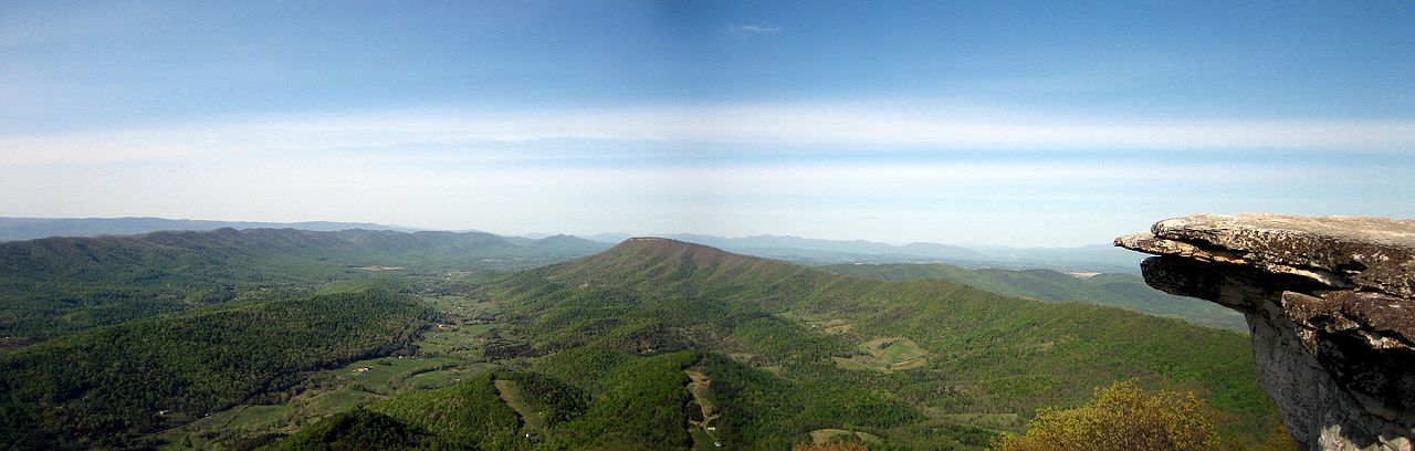
McAfee Knob is Virginia’s hiking icon. The rock ledge that juts out over the valley has appeared in more trail magazines, Instagram feeds, and AT guidebooks than any other single spot on the 2,190-mile Appalachian Trail. The approach follows the AT from the Route 311 parking area through mixed hardwood forest on a well-maintained trail that climbs gradually before steepening in the final mile.
The summit area has multiple viewpoints. The iconic ledge — the one in every photograph — is an exposed rock shelf that extends out over the valley with a significant drop below. On busy days, hikers queue for the ledge photo. Beyond the main ledge, the summit ridge has additional viewpoints with different angles on the Catawba and Roanoke valleys. The full view sweeps from the Blue Ridge to the Alleghenies, with Tinker Cliffs visible to the north and Dragon’s Tooth to the south.
The trail is an out-and-back following AT white blazes. The descent retraces the ascent. The grade is moderate throughout — no scrambles, no technical sections, no surprises. The difficulty is in the total package: 8.8 miles and 1,700 feet of gain is a substantial day hike that exhausts hikers who underestimate the distance.
McAfee Knob is not the hardest hike in Virginia. It is not even the hardest hike on this section of the AT. What it is: a long, steady climb that rewards fitness and punishes overconfidence. The 8.8-mile round trip is longer than most day hikers expect, and the 1,700 feet of gain is spread out enough that you never feel like you are in a sprint but never get to cruise either. Budget 4 to 6 hours for the round trip depending on pace and time at the summit.
If you can handle Humpback Rocks comfortably, McAfee Knob adds distance but not difficulty per mile. If you have done Old Rag, McAfee is easier but longer. The trail itself is straightforward — the challenge is sustaining effort over 8+ miles.
Fall is the premium season. The Catawba Valley turns color in mid-October and the view from the ledge is peak Virginia hiking. October weekends are the busiest days of the year — the parking lot fills by 7:30 AM and the ledge becomes a photo queue. Spring is excellent and less crowded. Summer works with an early start but the exposed summit gets hot by mid-morning.
Weekday visits at any time of year transform the experience. The ledge that feels like a tourist attraction on a Saturday afternoon becomes a genuine wilderness overlook on a Tuesday morning. The hike is exactly the same. The experience is not.
The trailhead is on Route 311 near Catawba, about 20 minutes from Roanoke. The parking lot fills by 7:30 AM on weekends from April through November. There is no overflow parking. Plan to arrive early or go on a weekday. No entrance fee. Restrooms are available at the parking area. Cell service is adequate at the summit.
The trail follows AT white blazes and is well-maintained. Dogs are allowed on leash and handle the trail well — the grade is gentle enough for most dogs. Bring at least 2 liters of water per person for the 8.8-mile round trip. There are no reliable water sources on the upper trail. Trekking poles are optional but helpful on the descent.
McAfee Knob is one-third of the Virginia “Triple Crown” along with Dragon’s Tooth and Tinker Cliffs. Ambitious hikers do all three as separate day hikes over a weekend. The trailheads are within 30 minutes of each other.
McAfee Knob is famous for a reason, and the reason is the ledge. Standing on that rock shelf with the valley falling away below you is a physical experience that no amount of Instagram scrolling can replicate. The 4.4 miles of climbing fade from memory the moment the view opens. For AT thru-hikers walking from Georgia, McAfee is the first truly iconic viewpoint on the trail — the place where the AT stops being a forest walk and announces that it has destinations worth the mileage. For day hikers from Roanoke, it is the backyard summit that never gets old. Both groups are right.
LOWA Renegade EVO GTX MidGORE-TEX, 3 widths, resolableCheck price on Amazon →Hydro Flask Wide Mouth 32ozinsulated, durableCheck price on Amazon →Osprey Talon 22ventilated back, pole carryCheck price on Amazon →Adventure Medical Kits Ultralight Watertight .7day-hike specific, waterproofCheck price on Amazon →Black Diamond Spot 400-Rrechargeable, comfortableCheck price on Amazon → Patagonia Torrentshell 3L Jacketdurable, trail + everydayCheck price on Amazon →
 Darn Tough Hiker Micro Crew Midweightlifetime warrantyCheck price on Amazon →
 Black Diamond Pursuit Trekking Polescork grip, lightweightCheck price on Amazon →
 Sawyer Squeeze Water Filterultralight, standard threadsCheck price on Amazon →