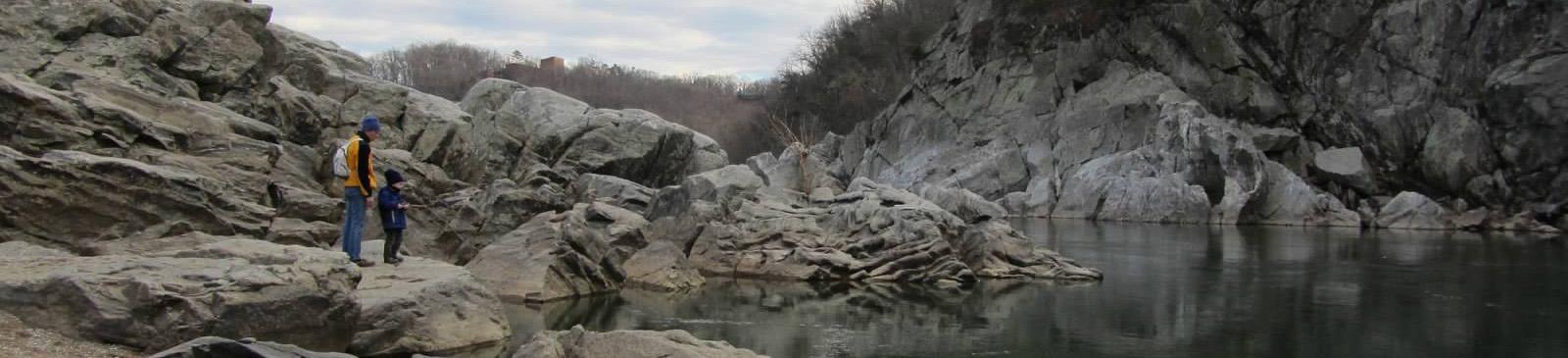
Billy Goat Trail — C&O Canal National Historical Park
Photo: National Park Service
(CC via Wikimedia)
 LOWA Renegade EVO GTX MidGORE-TEX, 3 widths, resolableCheck price on Amazon →
 Hydro Flask Wide Mouth 32ozinsulated, durableCheck price on Amazon →
 Osprey Talon 22ventilated back, pole carryCheck price on Amazon →
 Adventure Medical Kits Ultralight Watertight .7day-hike specific, waterproofCheck price on Amazon →
 Black Diamond Spot 400-Rrechargeable, comfortableCheck price on Amazon →
Billy Goat Trail (Section A) at a glance: A 3.8-mile loop along the Potomac River near Potomac, Maryland, in the Chesapeake & Ohio Canal National Historical Park. Rated challenging, and the number that matters isn’t the distance — it’s the roughly 1.7 miles of hands-on rock scrambling across Bear Island, including a steep cliff traverse that stops first-timers cold. Wear grippy shoes, skip it when the rock is wet or icy, arrive early for the Old Angler’s Inn lot, and expect the short mileage to take far longer than it reads.
The Billy Goat Trail is proof that a hike doesn’t need distance to be demanding. Its most famous stretch, Section A, runs just under two miles along the top of Bear Island above the Potomac River, and nearly all of it is boulder scrambling rather than walking. Hikers rate it among the best short outings near Washington, DC, and the reason is the mismatch between the map and the experience: 3.8 miles that hike like something much harder, with river gorge views that feel a world away from the flat towpath a few hundred yards inland.
The loop pairs two completely different trails. The outbound leg is Section A itself, a blue-blazed route that leaves the C&O Canal towpath and climbs onto the rocky spine of Bear Island. From there it becomes a near-continuous scramble over and between boulders, following blue blazes painted on the rock because the “trail” is often just the next reasonable line across the stone. The Park Service asks hikers to travel Section A in one direction to keep the bottlenecks moving, and following the blazes rather than improvising is what keeps people on route.
The signature obstacle is a stretch hikers call the Traverse, a steep near-vertical rock face above the river that you climb using hands, feet, and whatever holds present themselves. It is the single feature that defines the trail’s reputation, and it is where hesitant hikers back up while a line forms behind them. Between scrambles the route opens onto cliff-top views of the Potomac churning through Mather Gorge, which is the payoff that keeps people coming back.
The return leg could not be more different: once Section A rejoins the C&O Canal towpath, the loop closes on a flat, wide, shaded gravel path back to the start. That contrast, a strenuous rock scramble out and an easy stroll back, is part of why the loop works so well as a compact half-day outing.
Challenging, and harder than 3.8 miles has any right to be. This is not a hike measured in elevation gain; it’s measured in hands-on scrambling, and hikers consistently warn that the short distance is misleading. Moving over boulders is slow, physical work, and most people take two to three hours on the loop despite the modest mileage. Anyone expecting a quick nature walk is the person most likely to be surprised.
Footwear is the factor hikers bring up most. Sturdy shoes or boots with real grip make the scramble far more secure; smooth-soled sneakers turn it sketchy. The rock is also decisive in another way: it is genuinely dangerous when wet or icy, and hikers repeatedly advise skipping Section A after rain or in freezing conditions, when the same holds that feel solid in dry weather become slick. This is not a hike for small children or anyone uneasy with heights and exposure, given the cliff edges above the river.
The trail is open year-round, and the best conditions are dry ones. Spring and fall are the sweet spot, with comfortable temperatures, good grip on the rock, and the gorge at its most scenic. Summer is popular but hot and humid on the sun-exposed rock, with bugs picking up near the water, so an early start pays off doubly. Winter is viable on clear, dry days but genuinely hazardous whenever ice forms on the scramble; when in doubt in the cold months, the flat towpath makes a safe alternative.
Regardless of season, timing your arrival matters as much as the weather. This is one of the busiest hikes in the DC area, and the scramble develops bottlenecks at the harder moves once crowds build. Hikers who start early report a quieter trail and a faster, less congested Traverse; those who arrive mid-morning on a nice weekend often wait in line at the rock faces.
Parking is the main piece of planning. The small lot at Old Angler’s Inn is the closest access to Section A and fills early on weekends, so an early arrival is the reliable strategy. The larger option is the Great Falls Tavern entrance on the Maryland side, which has more parking and restrooms but charges a park entrance fee and adds towpath walking to reach the trail. Either way, arriving before mid-morning solves both the parking crunch and the crowds on the scramble.
Dogs are not permitted on Section A, since the scrambling and cliff exposure make it unsafe for them, and it’s an enforced rule that catches people off guard. Carry water, since there’s none on the rock and the exertion is higher than the distance suggests. Phones and loose gear are worth securing in a zipped pack rather than a pocket; hikers regularly mention dropping things between boulders on the harder moves. There are restrooms at the Great Falls Tavern area but none out on Section A itself.
The trailhead sits about 20 to 30 minutes from downtown Washington, which makes it one of the closest real adventures to the city, close enough for a morning outing yet wild enough to feel like a proper hike. Pairing it with the Great Falls overlooks, a short walk from the Tavern entrance, is the classic way to round out the visit.
Section A earns enthusiastic marks from the people who hike it — the large majority rate it a top short hike near the capital and point to the scramble itself as the draw, calling it more fun and more of a workout than they expected from under four miles. The steady caveat running through their accounts is respect for conditions: hikers who came in grippy shoes, skipped it when the rock was wet, and started early had the clean, exhilarating version of the outing.
That’s the honest read on the Billy Goat Trail. It is short, it is genuinely challenging, and the gap between those two facts is exactly what makes it worth doing. Wear the right shoes, pick a dry day, get there early, and Section A delivers a rock scramble as satisfying as any within easy reach of Washington, DC.
LOWA Renegade EVO GTX MidGORE-TEX, 3 widths, resolableCheck price on Amazon →Hydro Flask Wide Mouth 32ozinsulated, durableCheck price on Amazon →Osprey Talon 22ventilated back, pole carryCheck price on Amazon →Adventure Medical Kits Ultralight Watertight .7day-hike specific, waterproofCheck price on Amazon →Black Diamond Spot 400-Rrechargeable, comfortableCheck price on Amazon → Patagonia Torrentshell 3L Jacketdurable, trail + everydayCheck price on Amazon →
 Darn Tough Hiker Micro Crew Midweightlifetime warrantyCheck price on Amazon →
 Black Diamond Pursuit Trekking Polescork grip, lightweightCheck price on Amazon →
 Sawyer Squeeze Water Filterultralight, standard threadsCheck price on Amazon →


